Berne Maps and Orientation
(Berne, Switzerland)
Over 140,000 people currently call Berne their home and the Swiss capital is continually expanding. Berne is actually Switzerland's fourth-biggest city and can be found on the north-westerly side of the country, within the Swiss Plateau region of the Berne Canton.
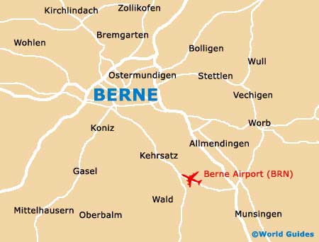
The city centre has grown up around the River Aare and many historical bridges now span this prominent waterway. Central Berne itself is quite compact and remains fully contained within a sharp bend of the River Aare. At the very mouth of this notable U-bend is the railway station, while close by are a number of the city's numerous sights.
Maps and Orientation of the City
Some areas of central Berne are now restricted to pedestrians only and also public transportation, so it is often simplest to leave your car at the hotel. Maps of the city are available at the outlets of Berne's tourist offices (Bern Tourismus), which are located at the railway station and also next to the bear pits, across the river. Also check out the bookshops on the Neuengasse and the Schauplatzgasse.
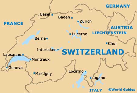
- Basel - 98 km / 61 miles (one hour and ten minutes, north)
- Besancon (France) - 177 km / 110 miles (two hours and 20 minutes, west)
- Burgdorf - 27 km / 17 miles (25 minutes, north-east)
- Fribourg - 34 km / 21 miles (30 minutes, south-west)
- Geneva - 155 km / 96 miles (one hour and 50 minutes, south-west)
- Grenchen - 47 km / 29 miles (55 minutes, north)
- Lausanne - 105 km / 65 miles (one hour and 20 minutes, south-west)
- Lucerne - 120 km / 75 miles (one hour and 25 minutes, east)
- Montreux - 88 km / 55 miles (one hour and five minutes, south-west)
- Mulhouse (France) - 130 km / 81 miles (one hour and 35 minutes, north)
- Spiez - 40 km / 25 miles (35 minutes, south)
- Thun - 31 km / 19 miles (26 minutes, south)
- Winterthur - 145 km / 90 miles (one hour and 50 minutes, north-east)
- Zurich - 125 km / 78 miles (one hour and 40 minutes, north-east)
Map of Switzerland
Map of Berne